


04 PERRY_LIGIONIER, Noble County, Indiana
About
Outline

Summary
| Unique Area Identifier | 579936 |
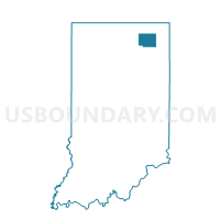
| Name | 04 PERRY_LIGIONIER |
| County | Noble County |
| State | Indiana |
| Area (square miles) | 1.05 |
| Land Area (square miles) | 1.05 |
| Water Area (square miles) | 0.00 |
| % of Land Area | 100.00 |
| % of Water Area | 0.00 |
| Latitude of the Internal Point | 41.47251870 |
| Longtitude of the Internal Point | -85.59399560 |
Maps


Graphs
Select a template below for downloading or customizing gragh for 04 PERRY_LIGIONIER, Noble County, Indiana


Neighbors
Neighoring Voting District (by Name) Neighboring Voting District on the Map
- 03 PERRY, Noble County, IN
- 05 PERRY_LIGIONIER, Noble County, IN
- 06 PERRY_LIGIONIER, Noble County, IN